Every box of lawn feed, seed or moss killer gives a rate per square metre, and most people guess the size of their lawn. Ten minutes with a tape, or a traced map, takes the guessing out of every product you buy.
How do you measure a lawn by hand?
Split it into shapes you can work out:
| Shape | Formula | Example |
|---|---|---|
| Rectangle | Length × width | 12 m × 8 m = 96 m² |
| Triangle | ½ × base × height | ½ × 6 m × 4 m = 12 m² |
| Circle | 3.14 × radius² | 3.14 × 2 m × 2 m = 12.6 m² |
Measure along the edges with a 30 m tape. Front and back gardens are separate areas.
What about curves, borders and trees?
Draw a rectangle over a curved section and take off the part that is border or path. Take off flower beds, the patio, paths and any bare ring under trees. Round to the nearest square metre.
How much of each product do you then need?
Multiply your area by the rate on the pack. A 145 m² lawn and a feed at 35 g/m² needs about 5 kg. The same works for seed, lime and moss killer. The full sum for feed, with NPK, is in How Much Lawn Feed Do You Need?
Turf is sold by the square metre. Add about 5 percent for cuts around curves.
How does measuring on a satellite map work?
You trace the outline of the lawn on an aerial photo, point by point, and the app works out the area. It is quicker than a tape for awkward shapes and easy to redo when you dig a new border.
The example lawn in the app is a back garden in Manchester drawn as one area:
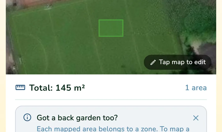
In What a Green Lawn you tap the map to place corners, drag them to adjust, and the area updates as you go, in square metres and square feet. Front and back gardens go in as separate zones, and the total drives the product amounts on the dashboard, so feed, lime, moss killer and seed quantities match your lawn. Trees and shadows on the photo can hide the edge, so check one side with a tape.
How accurate does it need to be?
Within 5 to 10 percent is fine. The risk is being far off: a lawn guessed at 100 m² that is really 145 m² gets a third less feed than intended, and one guessed at 200 m² gets too much, which is how scorched stripes happen. Measure once, write it down, and measure again when you change the garden.
What a Green Lawn keeps the mapped area with your lawn and turns it into amounts for each product, so you measure once and stop doing sums at the spreader.